Colorado Plateau

...now browsing by category


Donating to Navajo-Hopi COVID-19 relief

Friday, May 29th, 2020

In mid-April, Jackson Frishman and I launched a print sale in an effort to support the Navajo and Hopi tribes during the COVID-19 pandemic. We each offered a selection of prints for sale, with the net proceeds being donated entirely to an already successful GoFundMe.

Donating to the Navajo-Hopi COVID-19 relief fund.

The fundraiser was more successful that I could have imagined; thanks to you we were able to donate $1525 to the GoFundMe, which has raised over $4.4 million dollars so far. This money will be able to provide basic necessities to families on the Navajo and Hopi reservations who have been extraordinarily hard hit by the COVID-19 pandemic.

This part of the country holds a special place for both Jackson and myself. The landscape is beautiful, and so are the people. We’re both sincerely grateful for your purchase; together we were able to help a little for people who mean a lot.

Tones monochrome image of large sandstone towers in Death Valley.

Black rocks protruding up

Friday, July 5th, 2019

The Navajo or Diné Volcanic Field is a circle of volcanic formations lying roughly in the Four Corners region of the American Southwest. These peaks and ridges are striking in their own right, but are even more curious because of their juxtaposition with our image of what the Colorado Plateau should be.

The Colorado Plateau is synonymous with sandstone. We identify this region by massive cliffs, arches, hoodoos, and towers; people come from all over the world because there is nothing like these places anywhere else on Earth. It seems a bit incongruous, then, to drive through this region past numerous large volcanic towers, all of which stand in stark contrast to the surrounding sandstone formations.

Agathla Peak, part of the Diné Volcanic field in northern Arizona
Agathla Peak–Aghaałą́–near Monument Valley in northern Arizona

Black rocks protruding up

About 30 million years ago, as the rest of the Colorado Plateau was rising, several volcanic explosions occurred in northern Arizona and New Mexico. They occurred from Kayenta and Comb Ridge eastward to the Lukachukai Mountains and northwest New Mexico. From there, the semicircle of violent volcanic eruptions turned southward towards Zuni Pueblo. The plugs and dikes were covered for millions of years, but erosion has uncovered and sculpted these features, leaving behind the desert towers we know today. The Navajo simply refer to these towers as ‘black rocks protruding up’–tsézhiin ‘íí ‘áhí.

Black and white image of Church Rock, near Kayenta, Arizona
Church Rock with Agathla Peak in the background

Diné ethnogeology

In spite of its obscurity in a sandstone world–or perhaps because of it–tsézhiin ‘íí ‘áhí has a strong presence in Diné mythology. Ship Rock–Tsé Bitʼaʼí–the landmark monolith in northwestern New Mexico, for instance, is told to have been home to a giant winged monster or bird, Tsé Nináhálééh. Tsé Nináhálééh was one of many monsters that followed the Diné to their current homeland–Dinétah–when they emerged to this world from the previous one. This bird was vicious, and would throw its prey into mountainsides and rocks, crushing them before eating them.

Monster Slayer (Nayé̆nĕzganĭ) was one of two sons of Changing Woman, Yoołgaii Nádleehé, who fought and battled these monsters. He had a magic feather that protected him from the giant winged monster’s attacks and was able to defeat it. Today, Ship Rock itself is thought to be the body of the winged monster; the volcanic ridges running out to its sides are thought to be the monster’s wings.

Black and white image of shiprock in northern New Mexico under a partly cloudy sky
Ship Rock–Tsé Bitʼaʼí–where Monster Slayer destroyed the winged monster

The Diné volcanic field is the perfect example of how geologic features and obscurities capture our attention and work their way into our cultural DNA. A region’s geology plays a huge role in its phenology, giving rise to many of the things we relate to in the places we love (trees, flowers, even animals), even if the geology itself goes unnoticed. Stories are told, and are passed down through generations. These stories are what root us in a place. This is another way we as photographers are very much storytellers.

This intersection between geology, folklore, and sense of place has really captured my attention lately and I hope to write more about it. In the meantime, how has geology influenced your sense of place?

*The Navajo Creation Story is one drawn from several stories, many of which can only be told respectfully during the winter months. There are several texts that have attempted to pull these stories into one cohesive book. An excellent summary can be found here.

Happy 100th birthday to Grand Canyon National Park

Tuesday, February 26th, 2019

“The wonders of the Grand Canyon cannot be adequately represented in symbols of speech, nor by speech itself. The resources of the graphic art are taxed beyond their powers in attempting to portray its features. Language and illustration combined must fail.” – John Wesley Powell


Aside from a few family vacations when I was young, I only have glimpses in my memory of our national parks. However, that changed when I was 13 and went to Grand Canyon National Park for the first time. I visited with my Boy Scout troop on spring break for my first backpacking trip. I’m not sure of my rank in Scouting at the time, but as far as backpacking went, I was truly a tenderfoot.

Our first night, spent on the South Rim, was as snowy and cold. As such, we hit the trail the next morning with wet tents and cold feet. Two days later, I would be bailing water out of my tent for an entire afternoon in a torrential downpour on the North Kaibab trail. After a rocky start, though, the clouds lifted and we got to experience the tranquil beauty of Grand Canyon. The immense canyon showed us all four seasons over just a few days. I came out filthy, exhausted, and addicted. Addicted to our national parks, to the wilderness ethos, to a life dedicated to the outdoors. That trip changed my life, and I’m grateful for that.

Grand Canyon National Park remains one of my favorite places, and today is its 100th birthday! Over the course of its time as one of the crown jewels of the national parks, it has inspired millions. With the help of fellow defenders, Grand Canyon has weathered storms of its own. Tourism development, mining, and even dams have threatened Grand Canyon at some point during its tenure as a national park. Threats continue: there are active proposals to open portions of Grand Canyon to uranium mining (despite a ban currently in place). Grand Canyon National Park is also leading the way in acknowledging the long history of indigenous people in our national parks.

Despite the threats, one cannot help but stand in awe when faced with such immensity. Grand Canyon takes the visitor back in time, looking through Kaibab limestone, Coconino sandstone, Redwall and Muav limestone, and finally down to the bottom–to Vishnu schist, some of the oldest rock on earth. You can’t help but feel small there. The resilience and humility it instills in us makes Grand Canyon worth celebrating.

Here are a few of my favorite images from Grand Canyon over the years.

desert view sunrise, grand canyon national park
A winter evening at the south rim of the Grand Canyon
A dramatic sunset over the Grand Canyon, near Mather Point.  In this image, the South Kaibab Trail, Phantom Ranch, and the Tonto Shelf are all visible.  Grand Canyon National Park, Arizona
photo of sunrise with bright orange clouds and two rivers converging in a deep canyon
black and white photo of the little colorado river gorge as soon from the grand canyon south rim
colorado river near cape solitude in grand canyon national park

Open for business: conserving our public lands

Monday, February 4th, 2019

The federal government re-opened–somewhat comically–minutes after I finished writing my last blog post. I’m happy to see our government operating normally again. Most importantly, our National Parks and other public lands are being staffed again. During the shut down, people damaged some of our natural–collective–treasures, perhaps irreversibly. I still don’t truly understand that. The time for conserving our public lands is now, and there is at least one very tangible thing we can all do.

photo of snow on Jacob, one of the Patriarchs in Zion National Park, Utah

In an attempt to offset the doom and gloom in my last post, I thought I’d share some good news! One somewhat humorous bright spot from the government shutdown itself came from Point Reyes National Seashore. Elephant seals took over Drakes Beach. Females gave birth to several dozen pups there, meaning they aren’t leaving any time soon.

Back to Bears Ears

Arizona Congressman Ruben Gallego and New Mexico Congresswoman recently introduced the Bears Ears Expansion and Respect for Sovereignty Act (BEARS Act) to Congress. The BEARS Act would re-establish the full 1.9 million-acre Bears Ears National Monument as proposed by the Bears Ears Inter-Tribal Coalition in 2015. When President Obama designated Bears Ears National Monument in 2016, the boundaries more closely followed the footprint laid out in other legislation. For more on Bears Ears see previous blog posts here and here.

Support the Public Lands Policy Package

Perhaps the biggest thing that is worth watching right now is the Natural Resources Management Act (S.47) which Lisa Murkowski of Alaska recently introduced into Congress. This bill is good news for several good reasons. First, it has bipartisan support–California’s Dianne Feinstein authored a large part of it. A longtime champion of California’s deserts, Feinstein proposes the expansion of desert National Parks (like Death Valley), the expansion of existing Wilderness areas, and the creation of new ones (good news for my Wilderness Project!).

photo of a rising moon at sunset in the orocopia mountains of southern california

Second, S.47 would provide for the permanent adoption of the Land & Water Conservation Fund (LWCF). Congress initially funded the LWCF in 1965 with widespread bipartisan support. Since then, the LWCF has provided funds for all sorts of projects from the National Parks to city parks. Its funding expired last year and needs to be renewed, for the benefit of all Americans. Click here to urge your legislator to adopt S.47.

Elephant seals teach us that nature will persevere, regardless of our short-sighted actions. However, there is hope that we’ll be able to find common ground in conserving our public lands for generations to come.

In defense of Bears Ears National Monument

Thursday, May 11th, 2017

In my last blog post, I talked about Executive Order 13792, which orders a review of the national monuments, many of which in the West, established since 1996. This review is to ensure that they were created in accordance with the original intent of the Antiquities Act of 1906. The most pressing national monument “under review” is Bears Ears. The Department of Interior has opened the public comment period for this order, and for Bears Ears, it is only 15 days long. Please make your opinion heard; it is the only way for the the Secretary to hear our thoughts on this matter. Below is my letter about Bears Ears specifically.

Comments may be submitted online at http://www.regulations.gov by entering “DOI-2017-0002” in the Search bar and clicking “Search,” or by mail to Monument Review, MS-1530, U.S. Department of the Interior, 1849 C Street NW, Washington, DC 20240.


Secretary Zinke,

This letter regards Executive Order 13792, and specifically Bears Ears National Monument in southeastern Utah.

Bears Ears is home to several thousand archaeological sites. The sites themselves as well as the landscape are sacred to several Native American tribes. As such, the advocacy group Utah Diné Bikeyah formed from a collaborative effort between these tribes to protect this landscape. If there ever was a place that the Antiquities Act seems “written for,” Bears Ears most certainly is it. When President Obama designated the national monument in December 2016, it was was worthy of celebration because the preservation of these sites is now guaranteed as part of our national heritage. President Obama’s proclamation was also a testament to the sovereignty of these tribes, and the importance of their history to the nation.

Within the monument, recreational activities that were permissible before the monument designation are still allowed. With a permit, people can still gather firewood, herbs, and shrubs. Thus, the use and enjoyment of the land has not been affected. However, I am writing this letter to specifically address two other arguments against Bears Ears. The first is the size of the monument, and the economic impact that could have on local communities.

thunderstorm and fiery sunset at bears ears buttes in san juan county utah

In 2013, Representatives Rob Bishop and Jason Chaffetz put forward what they called the Public Lands Initiative (PLI), in which they would set aside part of the Bears Ears region as a national recreation area, which would essentially provide the same protections from oil and gas development or uranium mining as a monument designation under the Antiquities Act. Utah Diné Bikeyah proposed a similar, albeit larger, set of borders for their visualized national monument.

When the Obama administration designated Bears Ears National Monument, the borders they drafted more closely matched the national recreation area proposed in the PLI than those proposed by Utah Diné Bikeyah. What’s more, GIS data from the state of Utah show that the majority of oil and gas wells currently lie outside of the monument (possibly due to low success and complex terrain for drilling). The area’s most significant coal reserves lie completely outside of the monument boundaries. No areas within the monument are currently classified as having “high potential” for uranium mines either. When the monument was created, these data must surely have been available to the Obama administration.

Finally, critics have expressed concern for Utah’s schools. There are several inholdings of state trust land parcels within Bears Ears; they cannot be developed for mineral extraction because they lie within the monument. In 1996, when President Clinton designated Grand Staircase-Escalante National Monument, the federal government and the state eventually “swapped” for 139,000 acres of federal land that was outside of the monument with the Utah Trust Lands Administration for those types of private inholdings. In addition, the federal government paid the state of Utah $50 million. To date, the mineral extraction from that swapped land has yielded ~$1.7 billion in revenue for the state of Utah. Senator Bennett called this a “model for future land swaps,” and I agree with him. It was a win-win for all parties, and I believe it could work equally well in Bears Ears.

I grew up in the northwestern corner of New Mexico, and had many backpacking outings in the Bears Ears region. With my dad, and with my Boy Scout troop, we explored many of the canyons on Cedar Mesa, and saw many of the archaeological sites that are now protected. These are some of my fondest memories of time spent in the outdoors. Just like so many of our national parks and monuments, Bears Ears is one of our national treasures. As Westerners, we are bound to protect these lands; it is not in our nature to hastily exploit them for short-term gain. The preservation of Bears Ears keeps a promise to past and future generations, and is one that can transcend partisan politics. Please join me in standing with Bears Ears and making it our nation’s common ground.

photo of valley of the gods located in bears ears national monument

Welcome Bears Ears National Monument!

Sunday, February 5th, 2017

President Obama used the Antiquities Act to designate Bears Ears National Monument on December 28, 2016. The greater Bears Ears region and national monument includes Cedar Mesa, Comb Ridge, Valley of the Gods, Elk Ridge, Beef Basin, Indian Creek and Lockhart Basin, among others.

map of bears ears national monument

Credit: Stephanie Smith, Grand Canyon Trust

In large part, the designation of this monument was due to the arduous work of Utah Diné Bikéyah, a collective of five Native American tribes, who all hold parts of the new monument sacred. Bears Ears is the first truly Native American national monument, and these tribes’ collective heritage will now be protected for generations to come.

photograph of intact native american ruin in bears ears national monument

On a personal note, having grown up in the Four Corners region of the southwestern United States, many of my early backpacking trips were on Cedar Mesa and Grand Gulch. I can still remember discovering just a few of the hundreds of Ancestral Puebloan ruins and rock art in this area; these are some of my favorite memories of time spent in the outdoors. Today, whenever I visit my parents, who still live in northwestern New Mexico, the Bears Ears buttes are a landmark that I see to tell me I’m home. I’m very grateful to Utah Diné Bikéyah and others whose hard work made this monument possible. I’ve blogged many times on Bears Ears and Cedar Mesa (see posts here, here, and here, for instance).

photograph of clouds and rocks in valley of the gods utah

To celebrate the designation of Bears Ears, I’ve put together a collection of my images from the monument in one place. Hopefully I’ll be able to visit soon and add more.

Although I’ve published this gallery on social media, I have been a little bit slow in getting it to my blog. Since the monument was designated, it’s come under heavy fire (see links here and here for details). This criticism as a “land grab,” has come primarily from Utah Republican lawmakers who are also key leaders in the land transfer movement (see my blog post here for details). So, ironically, although Bears Ears has protection, it now needs your support more than ever. Please consider a donation directly to Utah Diné Bikéyah or the Grand Canyon Trust to help them combat efforts to reverse the monument designation, and contact your lawmakers to voice your opposition to it.

Lay of the Land

Friday, September 9th, 2016

“To rise above tree line is to go above thought, and after, the descent back into birdsong, bog orchids, willows, and firs is to sink into the preliterate parts of ourselves.” – Gretel Ehrlich


The entire summer seemed busy, but August flew by at an unusually rapid pace. My son and I drove from California to New Mexico to visit my parents; on our way out there we broke up the drive by spending a quiet and welcoming night at Navajo National Monument in northern Arizona. Four days after getting home from that trip, my girlfriend and I left on a trip to the north coast of California, visiting friends and family along the way. That leg of our travels culminated at South Lake Tahoe (I know, it’s not the north coast. Don’t ask.), and my dropping her at the airport in Reno to fly home.

From there, I drove south to eastern California, picked up Jackson Frishman at his house in the Deep Springs Valley, and we headed to eastern Nevada to backpack and photograph some Great Basin mountain ranges. By the time I got home from my second trip, my car had more than 3,000 new miles and I guess you could say I really got the lay of the land.

Over the years I’ve spent outdoors, I’ve become acutely aware of moments where time seems to stand still and that particular snapshot in time seems to transcend all others. In those particular rare moments, I’m overcome with an almost indescribable peace, feeling as though there’s no other place on earth I would rather–or should–be. I imagine that Buddhists would describe these moments as feeling very much like Nirvana, when one’s soul is freed from continuous rebirth, thus permanently taking its small place in the world. Put another way, these moments represent true peace.

I’ve always liked the above passage by Gretel Ehrlich because I think perhaps she used tree line as the metaphoric “rising above,” which has always seemed more eloquent than any way I’ve found to describe the feeling. My August travels only took me above topographical tree line a couple of times, but I felt like every turn of the journey somehow took me above Ehrlich’s metaphorical tree line, and I am indeed very fortunate for that. Here are a few of my favorite images from the last month or so.

engineer-mountain-wildflowers

Wildflowers in Colorado’s San Juan Mountains

navajo national monument sunrise

August sunrise in northern Arizona.

fort-bragg-coastline

Coastline along the rugged north coast of California

mendocino headlands sunset

A foggy sunset along California’s north coast

white mountains california

Sunrise over the Deep Springs Valley, California

white pine mountains sunset

Sunset on Currant Mountain, Nevada

Public Comments on the Grand Canyon Escalade Project

Thursday, September 1st, 2016

Earlier this week, Bill 0293-16 came before the Navajo Nation Council for approval. This bill contains the much-contested Grand Canyon Escalade Project, which is a massive development project on the east rim of the Grand Canyon near Grand Canyon National Park and the confluence of the Colorado and Little Colorado Rivers. Grand Canyon Escalade would be destructive on several levels, and I believe it should be opposed. The nonprofit group Save the Confluence has much more about the project on their website. 

The Navajo Nation Council is asking for public comments on the bill until 9/3/16 (which is not much time). You can submit your comments directly to the council by emailing them at comments@navajo-nsn.gov, with Bill 0293-16 in the subject line. 

Here are the comments I sent the council regarding Grand Canyon Escalade this morning.

Esteemed council members:

I am writing regarding the proposed Grand Canyon Escalade Project, which is up for approval as part of Bill 0293-16 and is currently before you.  As I understand it, the bill asks for approval of several items, including significant development of an area on the Grand Canyon’s east rim, near the confluence of the Colorado and Little Colorado Rivers, near the border of the Navajo Nation and Grand Canyon National Park. I understand this project would bring tourism and revenue to the Navajo Nation and as a non-tribal member of the community, I cannot speak for what the confluence means to the families and clans who live west of Highway 89. Nonetheless, I submit my comments for your consideration.

As places go, the Grand Canyon has faced its share of threats, and fortunately it has dodged some of the biggest ones (like the Bridge and Marble dams, whose progress was halted permanently in 1969). Today it seems like the West along with many other concerned people around the world is again holding its breath to see how the Grand Canyon Escalade Project will play out.

In 1993, I came to the Grand Canyon for the first time with my Boy Scout troop from Farmington, New Mexico. We backpacked into the Canyon from the South Rim; it was my first backpacking trip and I made many lifelong memories. Since then, I have become an avid backpacker, even taking my son into the wilderness for the first time when he was two. In an increasingly busy world, wilderness provides solitude, solace, and sanctuary. I have returned many times to the Grand Canyon since 1993 and in 2013 (twenty years after my first visit) I again found myself backpacking the Grand Canyon, only this time I was hiking to Cape Solitude to see the confluence–and the proposed site for Grand Canyon Escalade–myself.

The trip was impactful for me, and it became even more clear why the Grand Canyon Escalade simply cannot happen. During the entire trip–which comprised over 40 miles of hiking–we did not see an another human, not even another human footprint. We crossed paths with a herd of elk several times, but beyond that the silence was deafening and the dark night sky mesmerizing. The loneliness was aching and beautiful. Indeed, the area of Grand Canyon National Park that Cape Solitude lies in only sees about 50 visitors a year, which is a far cry from the much more busy main corridor along the South Rim; it feels like it is a world away.

Grand Canyon Escalade would be putting undue stress on an ecologically sensitive area and destroying one of nature’s cathedrals that has been billions of years in the making. This part of the Grand Canyon doesn’t need a lot of visitors for it to be special. Wilderness is like that. As much as we need food or water, I believe we need wild places. We do not need to visit them often, and when we do they should be difficult to get to, but simply knowing these places are there calms the nerves in the hustle and bustle of city life.

One night, decades ago, the famous Western author Edward Abbey sat at Cape Solitude and wrote, “We must preserve, not obliterate, what still remains of the American wilderness, the American hope, the American adventure.” Restraint is one of the rarest of virtues, but I ask that you exercise it here, thus preserving the east rim of the Grand Canyon, untouched and unmarred, for future generations.

Respectfully,

Greg Russell

Sunrise at the confluence of the Colorado and Little Colorado rivers the site of the proposed Grand Canyon Escalade project

The Confluence of the Colorado and Little Colorado Rivers

Backpacking a wilderness of rock

Monday, April 18th, 2016

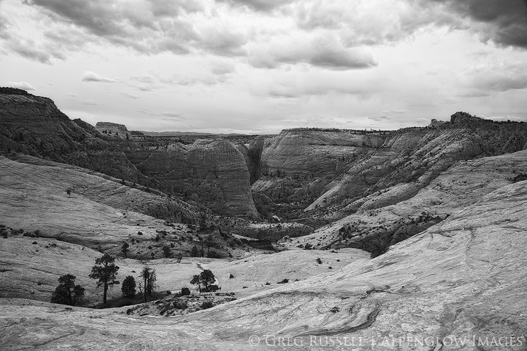
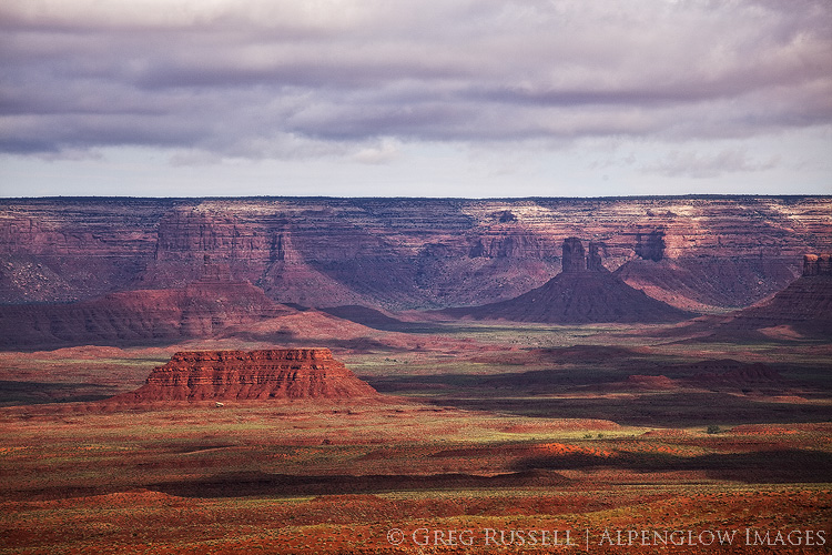
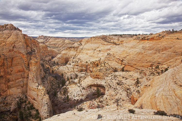
“The upper Escalante Canyons, in the northeastern reaches of the monument, are distinctive: in addition to several major arches and natural bridges, vivid geological features are laid bare in narrow, serpentine canyons, where erosion has exposed sandstone and shale deposits in shades of red, maroon, chocolate, tan, gray, and white. Such diverse objects make the monument outstanding for purposes of geologic study.” – Presidential Proclamation 6920 (establishing the Grand Staircase-Escalante National Monument), September 18, 1996


A wilderness of rock.  That’s what I imagined the historic Boulder Mail Trail would be when my dad and I set off to backpack it last month.  Indeed, to paraphrase Maynard Dixon, the upper Escalante Canyons expose the earth’s skeleton in a beautiful, if austere, way, exposing the earth’s skeleton.

The Boulder Mail Trail (which isn’t much of a trail at all), is the historic mail delivery route between the hamlets of Boulder and Escalante, Utah.  Highway 12, which now connects Boulder and Escalante, wasn’t paved until the 1970s, so the Mail Trail was the quickest route for quite some time.  All along the route, the old telegraph wire connecting these towns is also very obvious, although it’s fallen down in a few places.  The Mail Trail now lies almost entirely within the Grand Staircase-Escalante National Monument.

A couple of months ago, my dad asked if I wanted to go backpacking this spring, and of course I jumped at the chance.  A while back, I wrote a blog post about January trips with my dad, and I continue to feel really fortunate that my parents are both willing and able to be active.  It was our first backpacking trip together in many years, but it ended up being very fun, and just the right length for two old “geezers.”

For early spring, the weather was what one can expect on the Colorado Plateau: windy and cold.  Out of the wind in the sun, it was pleasant, but it was never too hot.  When we set off from the trailhead outside of Boulder, snow flurries were ducking in and out of the canyons on the Aquarius Plateau to the north, and looked like they might reach us within a few hours.  Dark skies to the west seemed to promise wet weather as well.  That’s better than boring blue skies, though, right?

Box-Death Hollow Wilderness, Utah

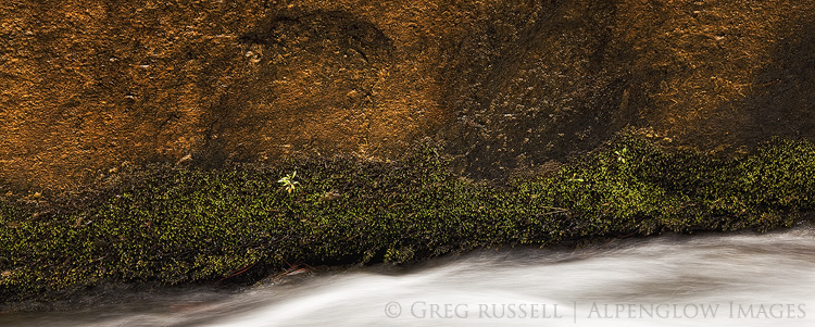
The Mail Trail is more than just a walk across sandstone, as it crosses a few fairly large tributaries of the Escalante River.  The most significant of these is Death Hollow, which despite the name is known for being a fun backpacking trip in its own right (save for the poison ivy it is also well known for!) and is about halfway along the Mail Trail. Death Hollow is surprisingly lush (hence the poison ivy), and is a wonderful riparian habitat tucked neatly away into the desert. We ended up camping in the bottom of the canyon amongst giant ponderosa pines because the weather was just spunky enough that we didn’t want to get blown off the rim and into the night as we slept.  We ended up falling asleep early, and despite a small sprinkle of rain and major sandblasting from the wind, the storm never really developed.

Box-Death Hollow Wilderness, Utah

The next morning, we hiked about a mile down Death Hollow before the route continued out the west side of the canyon, and towards Escalante.  We were able to see Escalante within a few hours, but it took much longer to wind our way down through the sandstone and back to the car we had parked at that end of the Mail Trail.  A quick run up to Boulder for the other car, and a beer (or two) at Hell’s Backbone Grill topped off the trip.

Box-Death Hollow Wilderness, Utah

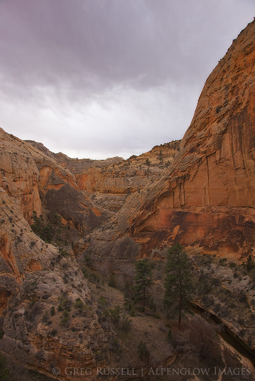
Despite the increased popularity of the Escalante area since President Clinton included it in his massive 1996 National Monument, the upper canyons of the Escalante River seem to be less visited than other more popular areas along the lower river.  It was nice to be able to experience a little bit of history, wilderness, and complete solitude for two days.  That said, solitude shouldn’t come as that big of a surprise–there isn’t a traffic signal for at least 100 miles from Escalante, and this is one of the most remote and rural places in the lower 48 states.  Combine that with world class scenery, and this wilderness of rock is truly an area to be cherished.

Box-Death Hollow Wilderness, Utah

Chaos Theory

Saturday, January 16th, 2016

In walking around southern California, I notice many people are starting to doubt the legitimacy of the rain this record El Niño was said to bring us.  Fair enough…we’ve had only one honest storm so far, but meteorologists say it is really just starting to come into its own. Despite not rearing its head too badly yet here, much of the Sierra Nevada is already at 100%+ of snowpack, and wildflowers are starting pop up in the desert.  More on that in a minute though.

At the end of fall, right before Christmas, I made a quick trip to the Grand Canyon.  While there, I got to experience a fairly stormy day on the south rim, complete with howling winds, whiteout conditions and closed roads.  A couple of images from that trip easily made my Favorites of 2015.  Then, Jackson Frishman and I headed to Death Valley National Park, and the weather was equally spunky.  There was no snow in the valley, but there was plenty of rain, great clouds, and even a few surprises thrown in along the way.

Visiting the Grand Canyon and Death Valley so closely together in time is sort of a surreal experience.  As if I had lost it, I quickly regained my appreciation for deep geological time.  Nearly 75 million years ago during the Laramide Orogeny, the Colorado Plateau was pushed upward nearly two miles and the Colorado River (which flowed from the newly formed Rocky Mountains) started to cut into the rock, forming the Grand Canyon.  Today, the river has cut about as deeply as it can go–to the basement Vishnu Schists–giving us a look back in time about 1.7 billion years.

Death Valley’s geologic story is a bit more complex (and violent), but as the Vishnu basement rocks in the Grand Canyon were being formed, Death Valley was already in a state of unrest, with rocks in certain areas being twisted and folded.  One area of particularly complex folding has been dubbed the “Amargosa Chaos” and is found in the southern end of the Black Mountains.  Fold, fold, fold…then separate.  That’s how the Basin and Range Province creates its mountain ranges–plates are pulled apart until they tilt upward creating massive mountain ranges with deep valleys between them.  In this part of North America, as John McPhee writes, the continent is literally being pulled apart.

You also start to understand a scale of spatial immensity in these two places.  While the Grand Canyon is typically thought of as the “deep” canyon at around 6,000 feet, it’s got nothing on Death Valley, which is over two miles deep (at its deepest).  If you’re not interested geology (I know…how can you not be?), it might be just as easy to stand in awe of both of these places, allowing yourself to feel small, both as a part of the landscape, and as barely-a-blip in geological time.

It’s worth noting briefly that while spring on the Grand Canyon’s rim is a few months off, it’s already happening in (especially) the southern end of Death Valley.  Jackson and I saw fields of Desert Gold (Geraea canescens) that created a wonderful lace-work pattern among the volcanic rocks in the southern Black Mountains.  All of the other usual suspects were starting to bloom as well, but are several weeks off from peak.  Hopefully some dreary, drizzly conditions continue in Death Valley, and it’s got the possibility of becoming a very good year for wildflowers.  Jackson has several photos and more commentary on his blog as well.

A winter evening at the south rim of the Grand Canyon

Death Valley mountains and wildflowers

Stormy winter morning on the south rim of the Grand Canyon

Salt Creek Hills, Death Valley