The Big Maria Mountains are just north of Blythe, California and run parallel to the Colorado River. From the high point of the range, you might think you could throw a rock and hit Arizona. Two Wildernesses protect the range: the Big Maria Mountains Wilderness and the Rice Valley Wilderness. I enjoyed some socially-distanced time in the Big Maria Mountain Wilderness at the end of 2020–a peaceful end to a very crazy year.
The Big Maria Mountains Wilderness was designated in 1994 and protects its namesake range. The Big Marias loom over the northern skyline of Blythe which, thanks to the Colorado River, is a small farm community in eastern Riverside County on the Arizona border.
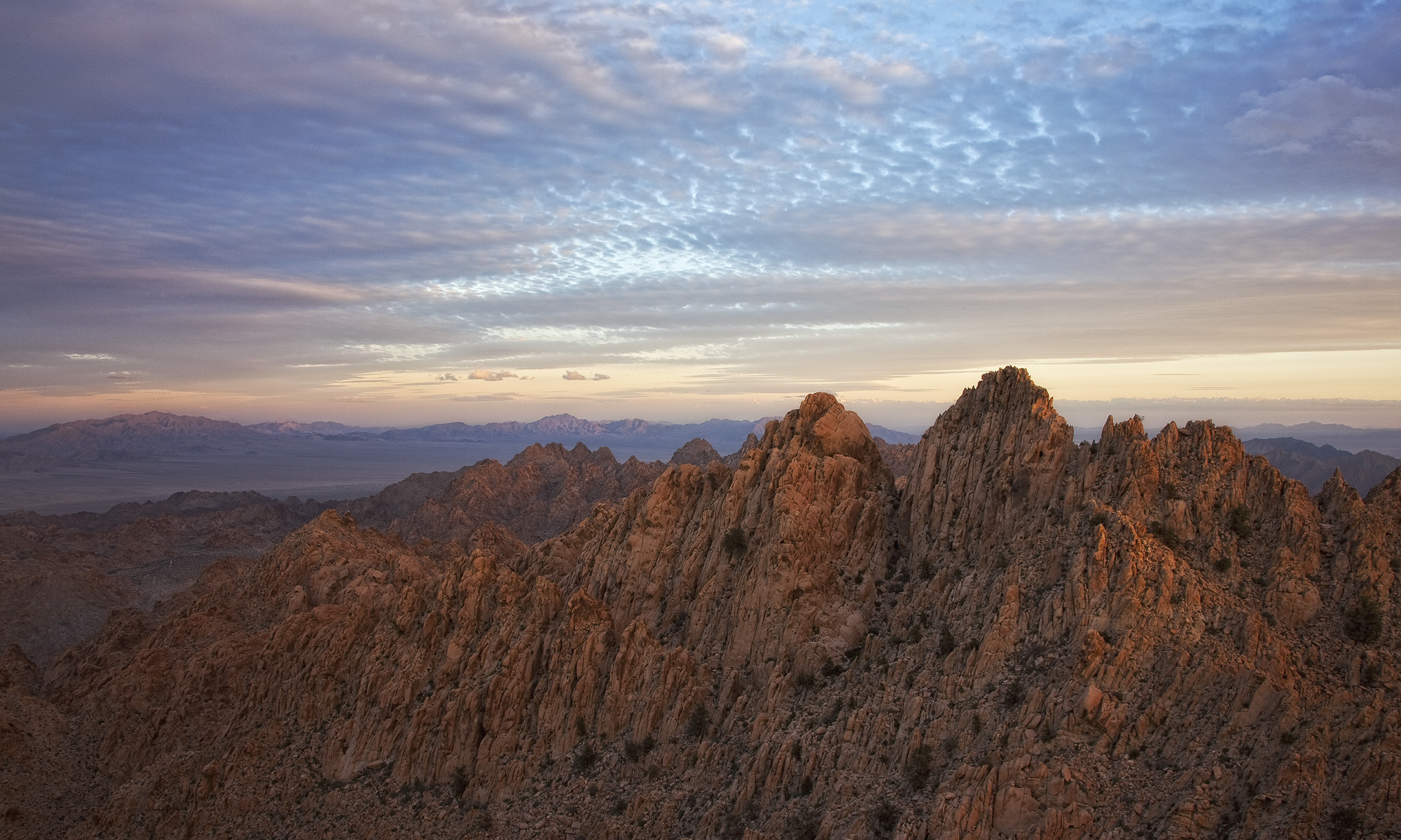
Driving north out of Blythe, the sharp peaks of the Big Marias become even more pronounced. Most desert ranges are steep, but the almost vertical eastern face and craggy ridgelines of the Big Marias are especially striking.

A geologic anomaly
During North America’s geologic infancy, The Farallon Plate collided with the North American Plate, essentially adding California to the continent. As the Farallon Plate moved eastward, it caused compression in primarily an east-west direction. This helps to explain the fact that many Southern California mountain ranges align on an east-west axis. However, at one point the direction of this compression shifted to a north-south direction, causing some ranges like the Big Marias orient 90 degrees to the others. The Riverside Mountains, and Palen and McCoy ranges also trend north-south and are part of this contortion.


This “line” of north-south trending mountain ranges is what geologists call the Maria Fold and Thrust Belt (MFTB). Because the now nonexistent fault exposed rock from the North American Plate along the MFTB, you find interesting granite washes not really consistent with what you might expect to find in a desert mountain range. The MFTB also acts as a sort of ecological “dividing line” for several species. For instance, the range of the California Fan Palm does not extend north of the MFTB.

Water is life
On my visit, I enjoyed a hike in one of the granite-bottomed canyons in the Big Marias. It felt good to shake some quarantine cobwebs out of my legs. At one turn in the canyon, my senses became momentarily confused by petrichor–the smell you often associate with rain. Southern California hasn’t seen rain in months. A few minutes later, I discovered its source: a small pool of water. Despite a rainless few months, several hundred milliliters of water persisted of a small granite bowl. This small amount of water brought much-needed life source to the desert. Judging from the scat in the immediate area, I’m guessing it’s a popular place.

Water makes life in the desert possible. Some plant species, like the Alverson’s foxtail cactus (Escobaria vivipara) and California barrel cactus (Ferocactus cylindraceus) (both native to the Big Marias) thrive in dry conditions, gathering water through extensive root systems. However, the rich human history of the area suggests long-term reliance on water. Rock art from multiple cultures like the Chemehuevi, Cahuilla, Southern Paiute, Serrano, and Quechan dot the landscape. In addition persistent water holes in the canyons, the Colorado River would have been a major site of settlement.


Today, of course, we bleed the Colorado River to its bone. Blythe marks the beginning of the Colorado River Aqueduct. Driving through town, you cross several canals filled with water from Colorado and Utah. Bright green fields are striking and incongruous with the landscape. It’s insulting to imply that the Colorado River makes it to its mouth. We take it all.
Areas of Critical Environmental Concern
Areas of Critical Environmental Concern (ACEC) are designated from a directive in the Federal Lands Policy and Management Act (FLPMA). The Bureau of Land Management uses this designation to protect special ecological or cultural resources. The Big Maria Mountain Wilderness is part of the larger Big Maria ACEC.
Another part of the Big Maria ACEC, but not in the wilderness itself is perhaps the most curious thing about the Big Maria region: the Blythe Intaglios. These massive geoglyphs are found on the alluvial plain between the eastern scarp of the Big Marias and the Colorado River. This is the largest concentration of geoglyphs in North America. None of the indigenous cultures of the Colorado River Valley claim to have made them. Their origin remains a mystery. Enjoying the Blythe Intaglios involves a walk of only a few hundred yards.

I love all the beauty you’ve captured with your photos and I thank you for sharing. I lived in Riverside for many years and never saw everything you’ve seen. Thanks again.
Cheryl, thank you for your comment! I’ve lived in Riverside 20 years and am learning how much there is to discover. I’m glad you’re enjoying the photos; I hope to have more in the next few months.