Arizona
...now browsing by category
Tuesday, June 7th, 2011
I remember my first trip to the Grand Canyon in 1992–it was not only my first backpacking trip ever, but also my first memorable trip to a national park. We went over spring break, in late March, and it was snowing hard at the South Rim when we arrived. I remember being cold and wet the night before our hike began, being completely terrified on the icy (and steep) South Kaibab trail the following morning, and sweating as we walked into Phantom Ranch later that afternoon. The rest of the trip was rainy, often very cold, and wet.
Despite all of that, I had a great time. A funny thing happens after outdoor experiences like this one: we seem to forget all of the “bad” parts of a trip, remembering the good things. Do the bad experiences really go away? Not completely: We learn from them. As a novice backpacker, I learned several things about hiking in poor weather; I learned them the hard way, but I survived.
The thing that stuck in my memory more than anything else from that first trip to the Grand Canyon was the magnificence of the place. The sheer drops, layers of sandstone, and of course the power of the Moenkopi-colored mud flowing in the Colorado River. I’ve returned to the Grand Canyon more than almost any other national park. During my first trip it was simply breathtaking; since then it has become breathgiving.
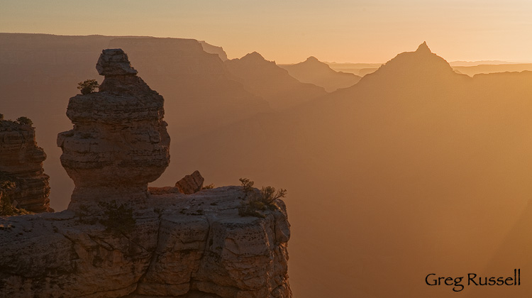
Vishnu's Sun Salutation, May 2011
Since 1992, I’ve backpacked the Grand Canyon once more, and have camped on the rim multiple times. Each time I say to myself, “Why don’t I visit more often?” Yes, its packed with people, especially on the holiday weekends when I find time to visit, but there’s a magnificent peacefulness that surrounds it. There are small pockets, places, you can go and hide, and despite the hordes, its almost as if you have this huge amphitheater to yourself.
Just like so many other geologic wonders on the Colorado Plateau, there really is nothing like the Grand Canyon on earth. Although I’ve enjoyed it for 19 years, I just now have images of it. Click the image or here to see the rest.
Posted in Arizona, locations, national park, Personal, southwest | 21 Responses »
Tags: Arizona, geology, grand canyon, landscape photography, nature photography, sunrise photo, sunset photo
Tuesday, March 1st, 2011
Despite some of you feeling like you’ve been stuck in a perpetual winter, and others wondering why winter never really seemed to arrive this year, spring is definitely on its way. Here in southern California–earlier than other parts of the country–spring wildflowers are already beginning, and will be continuing for at least the next month. However, as I’ve learned, those wildflowers are more complicated than one may think.
Rain is the most important, and most obvious, ingredient to making wildflowers. However, the pattern in which that rain comes is very important. For instance, last year, we had a lot of rain during late fall in southern California, but a very dry December and January didn’t leave us any flowers. It seems that the good years have a significant fall/early winter rain, and a “primer” in the spring. This year, that’s been the pattern, and there is hope of a great wildflower year.
This month’s image was made just a few days ago in Phoenix, on the tail end of a strong Pacific storm that swept through the area. I love the way the light played on the distant clouds. So, with the hope of a beautiful spring wildflower season, I hope you enjoy this month’s image.
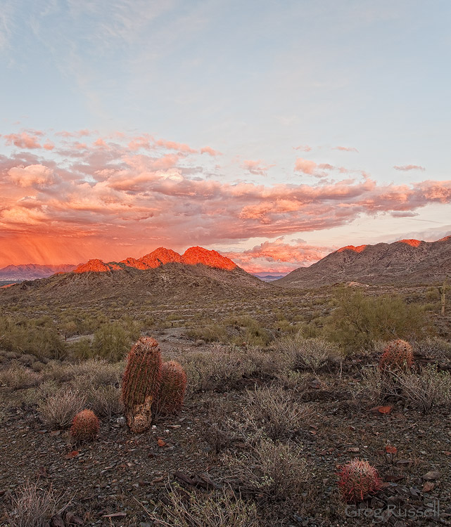
Sonoran Sunset II, February 2011
If you are interested in learning more about where to find the bloom in your area of the southwest, there are several great resources available:
- Desert USA has a hotsheet that’s updated regularly: click here.
- Ron Niebrugge spends a few weeks each spring in the southwest; he posts occasional wildflower updates on his blog.
- The Theodore Payne Foundation publishes a weekly wildflower hotline (mostly for areas in southern Arizona).
Living in southern California, I’ll be watching Anza Borrego Desert State Park, and Death Valley and Joshua Tree National Parks pretty closely over the next few weeks. However, its noteworthy that Saharan Wild Mustard, an exotic invasive species, is taking over much of what used to be the finest wildflower habitat in the area. I suspect many of the last strongholds will be taken over by this plant in the next few years.
Posted in Arizona, Photo of the month, southwest | 5 Responses »
Tags: Arizona, fine art, landscape photography, sunset photo
Tuesday, February 22nd, 2011
This past weekend, we traveled to the Phoenix area to visit family. Sunday night, the tail end of a strong Pacific storm was passing through the area and I hoped the sunset would be good because of several large clouds and storm cells still moving through the area. I threw my camera bag in the car and drove to Phoenix Mountain Reserve, part of the municipal park system in metro Phoenix.
Once I arrived, I hiked a short distance to a good vantage point, where I could see to the east, and mostly to the west and waited for the light to change. Because of the speed of the storm, conditions in the sky were changing extremely rapidly–usually not remaining static long enough for me to change lenses! As I’d hoped, the sunset was a success.
I’ve written before about the importance of finding your own little wild places. One thing I was grateful for in Phoenix was the ability to escape to an area to shoot beautiful landscape photographs in the middle of a large metropolitan area. I know some cities are incorporating open space initiatives into their long-term planning; I’m not sure what the status of Phoenix’s goals is, but I am grateful for the spaces that are there!
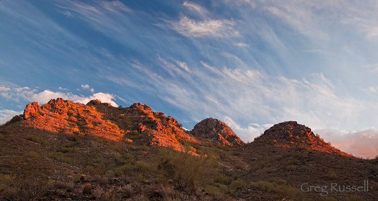
Sonoran Sunset, February 2011
Posted in Arizona, locations | 7 Responses »
Tags: Arizona, fine art, landscape photography, sonoran desert, sunset photo
Wednesday, February 9th, 2011
Often, the best traveling companions have a lot to teach you. My friend Brent is one of those guys. I can’t remember a trip with him where there wasn’t some sort of field guide pulled out for most of the drive, and I was busy learning about the natural history or some other facet of the land. On one road trip to Utah, we had the “Roadside Geology of Utah” out for 90% of the drive. Although I got tired of the updates at every mile marker, I have to admit that I missed Utah (and the updates) when we crossed the state line into Arizona. I definitely learned some geology on that trip, and I have a greater appreciation of it now.
Geology, as a science, studies the forces responsible for shaping and changing the earth. Sometimes those shapes and changes can simply be otherworldly. On my recent visit to the Vermillion Cliffs-Paria River Wilderness in northern Arizona, I was able to witness the magnificent results of some of these forces firsthand.
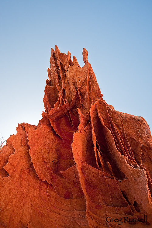
On a hike early one morning, we found ourselves on a small sandstone plateau. The sandstone was beautifully colored, but what really grabbed my attention were the bizarre rock formations. They reminded me of some petrified prehistoric gargoyle or ruins of an ancient civilization.
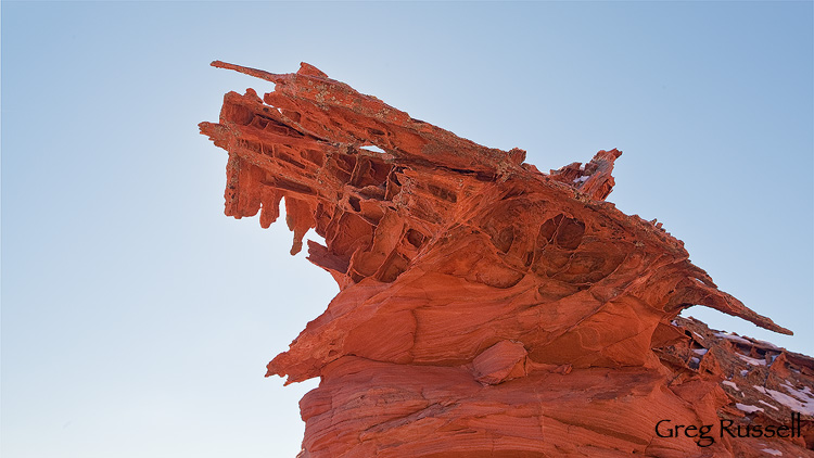
Gargoyle, January 2011
What’s happening in this image (and the one below) is called boxwork. The idea is that the sandstone was fractured at some point, and then some sort of fluid intruded and precipitated out, but it was more completely lithified so the surrounding rock eroded before the boxwork. I’m not entirely sure what intruded (calcite?), but it does make for very cool formations. I hope you enjoy the images.
Broken Cathedral, January 2011
Posted in Arizona, locations, southwest, utah | 9 Responses »
Tags: Arizona, fine art, geology, landscape photography, nature photography, utah
Friday, February 4th, 2011
Hollywood and mis-informed artists.
Made the saguaro a Texas Icon.
But the saguaro only grows in Arizona.
Where people’ve got em’ out on their lawn.
The Reverend Horton Heat
Indeed, its true. Often thought of as a symbol of the American West, the saguaro cactus (Carnegiea gigantea) is confined to the Sonoran Desert in southern Arizona, and southward into the states of Sonora and Baja, in Mexico. However, despite its somewhat limited geographic range, the saguaro still symbolizes much of what we associate with the American West, like resilience and fortitude. Saguaros can grow quickly, even in the hot, dry environment of southern Arizona. On young plants, the spines can grow up to a millimeter a day. In addition, they’re long-lived. They don’t even start branching until they’re several decades old.
Even after their death, the skeletons of these magnificent cacti stand strong against the elements, preserved by the dry desert air. I found a couple of cacti skeletons on a recent trip to Phoenix. I thought the lines they made were artful, graceful, almost sensuous.
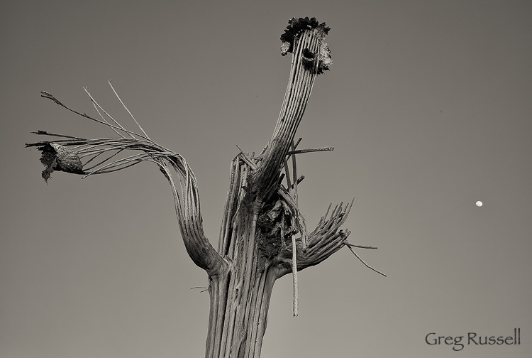
Saguaro Skeleton I, January 2011
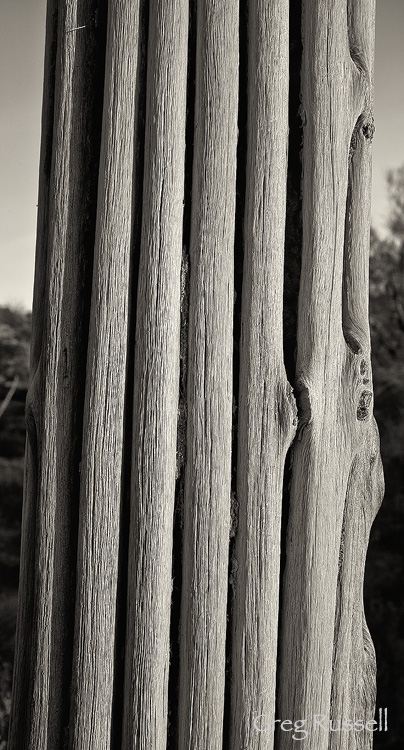
Saguaro Skeleton II, January 2011
Posted in Arizona, locations, national park | 14 Responses »
Tags: black and white, landscape photography, moon, moonrise photo, nature photography, saguaro cactus, sepia
Tuesday, February 1st, 2011
January is already over, and the sun is starting to creep more and more northward in the sky every day. Photographically, January was productive, and I’m excited to share some new images with you in the next couple of weeks. February’s image of the month is an intimate landscape from a wildly popular location on the Utah-Arizona border. During the first week of 2011, we traveled to Page, Arizona to visit the Paria River-Vermillion Cliffs Wilderness. Never heard of it? Perhaps not, but I’d be willing to bet you’ve seen images from it. The area’s crown jewel is “The Wave,” which draws huge numbers of tourists every year.
We began our trip by hiking into The Wave, and it holds up to its expectations: its stunning. The Wave and surrounding Coyote Buttes North has some of the most striking geological formations in North America. It should come as no surprise, then, that The Wave is also heavily photographed. Confined to a small area, I think it would be nearly impossible to come up with a novel composition from The Wave itself. While there, I snapped a few images, and enjoyed the surrounding area. It may sound like heresy to some people, but I enjoyed some of the alcoves around The Wave more. In fact, judging by the paucity of footprints, I found some fantastic locations that seem to hardly get visited just a few hundred feet away!
After enjoying this lovely area, we visited some other canyons in the area, and that’s where I found this month’s image. One of the things I’ll blog about soon is the diversity of sandstone in this area–amazing, whimsical formations and colors abound. I really liked the way the sandstone “windows” here contrasted with the ice below. I hope you enjoy it too.
Also, I wanted to mention that yesterday I had the honor of being featured by David Hyde over at the Landscape Photography Blogger. Over there, David primarily showcases the work of his father, Philip Hyde, the pioneering color landscape photographer. Head on over and check out the feature as well as some of David’s other blog posts. I think you’ll quickly learn that if you don’t already read regularly, you’ll want to.
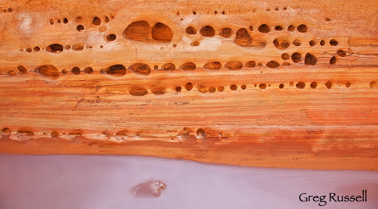
Ice underneath, January 2011
Posted in Arizona, Photo of the month, utah | 6 Responses »
Tags: canyon, fine art, Grand Staircase-Escalante, landscape photography, nature photography, stock photo, utah
Monday, March 1st, 2010
March’s Photo of the Month comes from Lost Dutchman State Park near Phoenix, Arizona. I visited the park in January while my wife was helping her sister plan for the upcoming arrival of our niece. In addition to the proximity to the greater Phoenix area and huge selection of hiking trails, the main draw of Lost Dutchman has got to be the rugged and beautiful Superstition Mountains rising out of the desert floor abruptly and confidently.
This month’s photograph shows the western flank of the Superstitions bathed in warm late afternoon light. I chose to use this cholla skeleton as a FG element because it seemed to be pointing me to a fantastic composition!
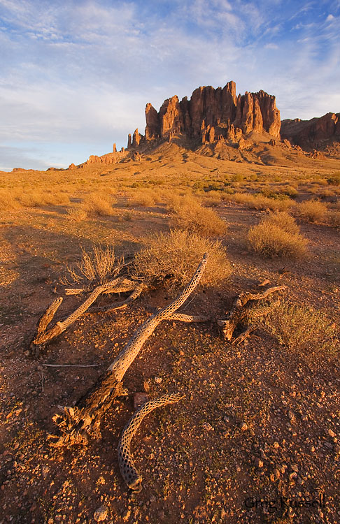
Western Flank of the Superstitions, January 2010
If you clicked on the link to Lost Dutchman State Park above, you couldn’t miss the red box informing us that the park will be closing indefinitely on June 3, 2010. Apparently, that part of Arizona’s budget has lost a significant amount of money during restructuring, causing the closure. I think the restriction of access to any open space is a great loss to us as a community. It prevents us from enjoying our parks, but more importantly it robs us of a chance to connect with the land, and wild places. I hope the Arizona government finds a way to keep their state parks open, or at the very least, to reopen them as soon as possible.
You can see all of my photos from the Superstition Mountains here.
Posted in Arizona, General, locations, Personal, Photo of the month | 4 Responses »
Tags: Arizona, conservation, fine art, landscape photography, nature photography, sunset photo
Thursday, February 18th, 2010
Sometimes the best-laid plans just don’t come to fruition. On our recent visit to Phoenix, I planned to get up very early (i.e. ~4am) drive to the Peralta Canyon trailhead and hike ~3 miles to the Weaver’s Needle Overlook to watch the sun come up, and to get that really sweet crepuscular light that happens in the desert. Easy enough, right? I ended up having a couple of roadblocks on my journey to ‘the Supes’.
- Roadblock #1. Two days before I intended to hike, I came down with the worst head cold I’ve had in several years. I’ll spare you the mucus-y details, but use of my nostrils was completely nonexistent, and my head felt like it was completely detached from my body. As a result, a 4am departure time didn’t seem feasible. I settled on getting up at 4:50am, figuring that if everything went smoothly, I’d still make it up to the overlook by 7:15am sunrise.
- Roadblock #2. Of course everything didn’t go smoothly. I really like Phoenix–its a great town, and its super easy to navigate as the streets are laid out in a logical grid pattern. That said, there are exceptions, and a poorly marked detour can throw an out-of-towner like me out of whack. Driving from my sister-in-law’s house, I wanted to connect from I-10 to US Hwy 60 to drive to the Superstitions. The connector ramp was closed, and the flashing sign said to take I-10 to McClintock instead. OK. After driving nearly 15 miles south (I wanted to go east), I finally stopped and asked for directions. I got on my way then. OK, well, that cost me about 15 minutes. But if I really hoof it, I can make it, right?
- Roadblock #3. I finally made it to the Peralta Road east of Apache Junction, and as I began driving the 7 miles toward the trailhead I was met by school buses. Lots of them. School buses…on a Forest Service road on a Sunday. What doesn’t compute here? After I met the school buses, I was met by runners. Lots of them. It turns out it was the annual running of the Lost Dutchman Marathon, and I was driving up their course! After slowly navigating several hundred finish-line-bound runners, I finally made it to the trailhead about 6:50am–25 minutes before sunrise.
I like to say that I’m a pretty fast hiker, but I’m not that fast. I didn’t make it to my destination by sunrise, but the hike was nice, and in hindsight the chain of events I encountered getting to the trailhead were almost comical. I even ended up with a nice photo or two out of the deal. It was definitely a good lesson not to take things so seriously. Things won’t always come together as you planned, but if you fail to see the forest for the few negative trees, you’ll miss out on some great experiences.
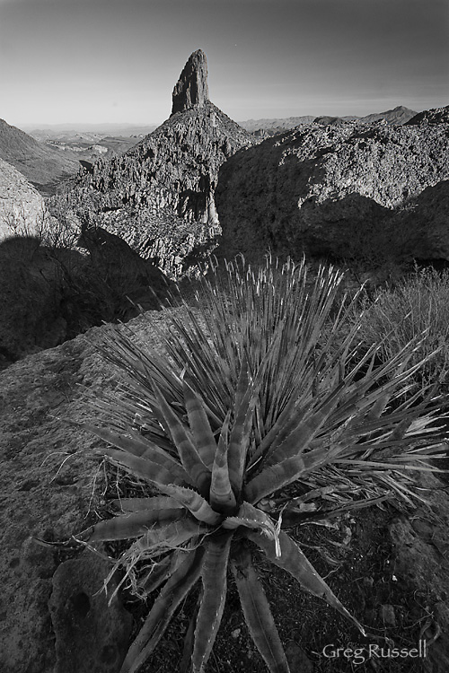
Weaver's Needle from Weaver's Outlook Ridge, February 2010
Posted in Arizona, locations, Personal | 2 Responses »
Tags: Arizona, canyon, fine art, hiking, landscape photography, nature photography, stock photo, sunrise photo, superstition mountains
Monday, February 15th, 2010
A few years ago I had the opportunity to go backpacking for a week in the Superstition Wilderness east of Phoenix. Two things struck me then about this area: its stunningly beautiful, and it doesn’t matter how you slice it, this is one rugged area. Although I was “into” photography at the time, I didn’t carry a camera with me, and since then I’ve been itching to get back to those mighty Superstitions.
My wife’s sister lives in Phoenix, and we’ve found ourselves here visiting a few times this winter. Its given me an opportunity to revisit these mountains. In January, I visited the Lost Dutchman State Park*, and hiked around the western flank of this magnificent range. I had a fantastic sunset, and had the opportunity to get a short hike in–up the Siphon Gulch trail.
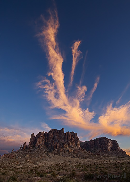
Cloud above the western flank of the Superstition Mountains, January 2010
Yesterday morning, I was able to visit the Superstitions again. This time, I drove to the eastern side of the range and hiked up the (very) popular Peralta trail to photograph Weaver’s Needle. I wanted the morning light on this spire, so I was on the trail before sunrise. It was a good thing too: the trail’s proximity to the greater Phoenix area makes it extremely busy. On my way down, I must have passed 50 people on their way up! My early start ensured I got good light on my subject, but also that I got the place to myself. The solitude was very rewarding.
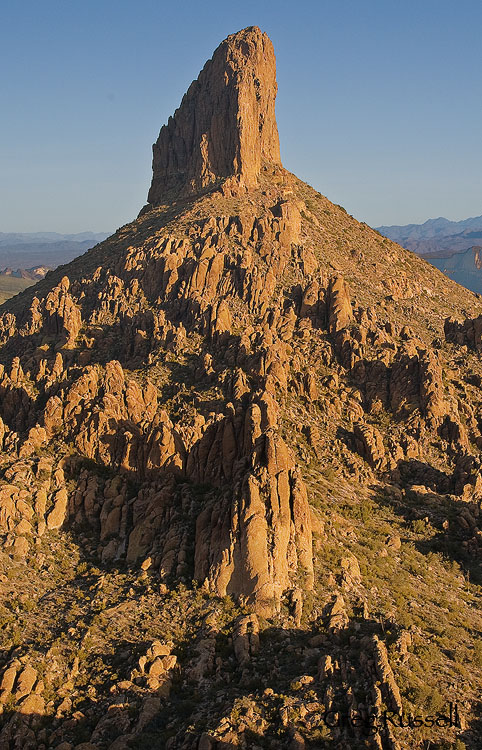
Weaver's Needle, February 2010
After visiting this place again after several years, I can say that its just as beautiful as I remember it. I can also say that its just as rugged as I remember it! Man, this is one amazing place.
I’ll be sharing more images from the Superstitions over the next week, but in the meantime, you can view them all here.
Posted in Arizona, locations | 1 Response »
Tags: Arizona, fine art, landscape photography, nature photography, stock photo, sunset photo, superstition wilderness, superstitions
Tuesday, September 1st, 2009
On our end-of-the-summer camping trip to the Sierra Nevada I noticed many of the aspen trees at the higher elevations beginning to change color. Even though its been brutally hot here in southern California, I can *sort of* feel fall in the air, and its making me wistful for the change of seasons. In the spirit of the winter to come, this month’s photo is of Spider Rock in Canyon de Chelly National Monument. Spider Rock–Tsé Na´ashjéé´ii–is an impressive 800 foot tall monolith rising out of the floor of Canyon de Chelly is sacred to the Navajo people; Spider Woman, who taught the Navajo how to weave supposedly lives on top of the rock.
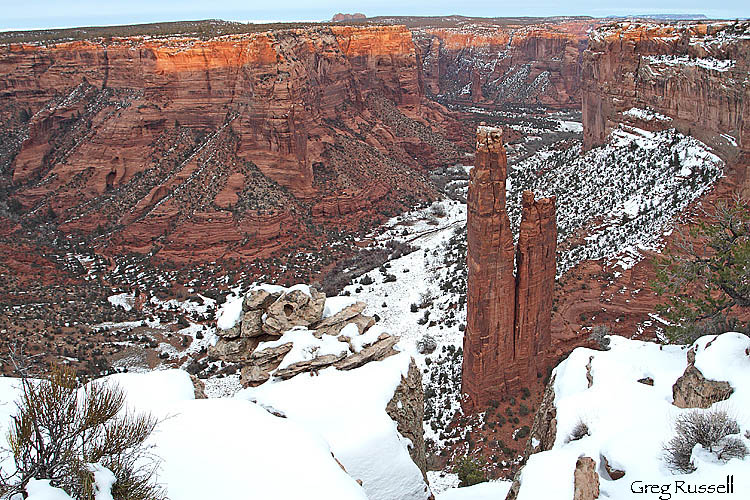 Spider Rock, Canyon de Chelly National Monument, December 2008
I was able to get this photograph on a somewhat grey afternoon, after driving from my sister-in-law’s house in Phoenix. Although I wanted a low-contrast shot, I was thinking that some color would be nice. Luckily, right before the sun dipped below the horizon for the day, it lit up the far cliffs giving me the splash of color I hoped for. I think (but am not sure) that the red sandstone here is part of the de Chelly formation, and I do love the glow it gets in late afternoon light.
Here’s to the a change of the seasons soon!
Posted in Arizona, locations, national park, Photo of the month | No Responses »
Tags: Arizona, canyon de chelly, fine art, landscape photography, natural phenomenon, nature photography, navajo, stock photo, sunset photo


